I meet many people in the landscape architecture community who have heard of i-Tree… but don’t really know what it does. Basically, i-Tree is a suite of tools designed to quantify the structure of a community forest as well as the environmental services provided by that forest. It can be used at a wide range of scales, from just an individual tree to all the trees in a city or even entire states. The i-Tree suite can do a lot more than most people probably realize, so in this blog I will give a brief overview of the many different kinds of things you can do with the i-Tree suite. Hopefully it will be kind of like unwrapping a gift, since the i-Tree suite is very valuable tool AND it is free!
There are many tools in the i-Tree suite. They are grouped into analysis and utility tools.
i-Tree Analysis Tools
The three core i-Tree analysis tools are i-Tree Eco, Streets, and Design.
All three quantify tree benefits. The main difference is in scale:
- i-Tree Eco can be used anywhere at any scale
- i-Tree Streets focuses on street trees
- i-Tree Design is used to quantify ecological benefits at a site scale.
i-Tree Eco
Based on a complete inventory or random plots, i-Tree Eco can analyze structure, function, and value of benefits of trees at any scale. Pollution and weather data, as well as dollar value for ecological services provided, are pre-programmed into i-Tree Eco for geographical locations in the US, Canada, and most of Australia.
The types of structural analysis provided includes:
- Number of trees by land use (chart)
- Number of trees per unit area by land use (chart)
- Species composition by DBH class
- Most important tree species
- Species richness, Shannon/Wiener Diversity Index
- Origin of trees by land use
- Condition of trees by species
- Condition of trees by land use
- Condition of trees by DBH and land use
- Leaf area of trees by land use (chart)
- Leaf area of trees per unit area by land use (chart)
- Leaf area and biomass of tree by DBH class and land use
- Leaf area and biomass of shrubs by land use
- Leaf area and biomass of trees and shrubs by land use
- Ground cover composition by land use
- Accuracy of land use predictions
The types of ecosystem services values provided include:
- Environmental services of trees by species
- Environmental services of trees by land use
- Environmental services of trees per unit area
- Carbon storage of trees by land use (chart)
- Carbon storage of trees per unit area by land use (chart)
- Annual carbon sequestration of trees per unit area by land use (chart)
- Energy effects of trees
- Avoided runoff of trees by species
- Avoided runoff of trees by land use
- Oxygen production of trees by land use (chart)
- Oxygen production of trees per unit area by land use (chart)
- Monthly pollutant removal by trees and shrubs
- Monthly pollutant removal by trees and shrubs (chart)
- Hourly pollutant removal by trees and shrubs (chart)
- Bioemissions of trees by species
- Bioemissions of trees by land use
Figure 1 shows a screenshot of the ecosystem services analysis that is available.
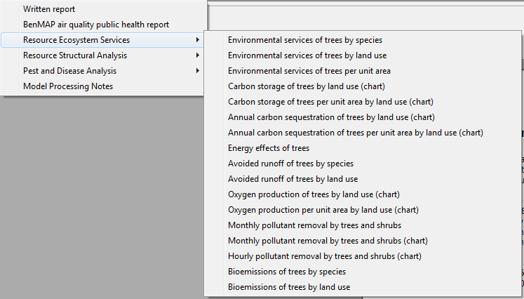
Figure 1: Screenshot of Ecosystem Services analysis available in i-Tree Eco
I-Tree Eco packages all this data into a handy report.
i-Tree Streets
i-Tree Streets analyzes structure, management needs, costs, and benefits of a municipality’s street trees based on a sample or complete inventory. It is a valuable tool to set priorities for maintaining street trees, planning tree replacements, and advocating for the value of street trees.
Cost benefit analysis includes:
- Energy benefits
- Stormwater benefits
- Air quality benefits
- Carbon dioxide benefits
- Carbon storage benefits
- Aesthetic benefits
- Management costs
- Net annual Benefits
Structural summary and analysis includes:
- Population summary
- Species distribution
- Relative age distribution
- Importance values
- Condition
- Relative performance index
- Stocking level
- Maintenance
- Land use
- Site type
- Conflicts
- Canopy cover
i-Tree Design
i-Tree Design is a very easy to use web tool that estimates benefits of individual or multiple, existing or proposed, trees at the site level on Google Maps imagery. It can be used, for example, to advocate for the value of existing or proposed trees, and as a design tool to compare benefits by potential new tree species, size and location alternatives. Benefits quantified by i-Tree design include tree benefits related to greenhouse gas mitigation, air quality improvements, and stormwater interception. Tree benefits can be estimated “for (a) the current year, (b) a user-specified forecast year sometime in the future, (c) the projected total benefits across that future timespan, and (d) the total benefits provided to date (based on estimated tree age).” (i-Tree website at http://www.itreetools.org/design.php, accessed 8/12/2014)
Other i-Tree analysis tools include i-Tree Hydro, Vue, and Canopy.
i-Tree Hydro (beta)
i-Tree Hydro (beta) analyzes the effects of tree cover and impervious cover on stream flow and water quality.
i-Tree Vue
i-Tree Vue uses the National Land Cover Database (NLCD) imagery to assess land cover, tree canopy, and ecological services provided by the urban forest. It can also model the effects of changing the current urban forest on benefits provided by the urban forest.
i-Tree Canopy
i-Tree Canopy is a fast and easy way to determine land cover types and percent tree cover world-wide based on google maps imagery. It also estimates values for air pollution reduction and capturing atmospheric carbon. The land cover data from i-Tree Canopy can also be used to estimate land cover inputs for i-Tree Hydro.
i-Tree Utility Tools
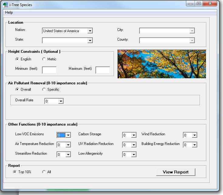
i-Tree Species
i-Tree Species is a tool used to select tree species based on desired environmental services, geographical location, and tree height constraints. The screenshot below shows the list of services the user ranks to select species.
i-Tree Storm
According to the i-Tree website, “i-Tree Storm establishes a standard method to assess widespread damage immediately after a severe storm in a simple, credible, and efficient manner. This assessment method is adaptable to various community types and sizes, and it provides information on the time and funds needed to mitigate storm damage.
Resources for More Information about i-Tree
The i-Tree tools are all available at this website:
https://www.itreetools.org/index.php
Many other resources are also available from that website, including:
- User manuals
- Reports from projects that have been completed using i-Tree
- Various webinars and presentations about i-Tree
If you are interested in i-Tree, make sure to check their website frequently. The i-Tree suite is updated regularly, and several new tools are currently being developed (like a wildlife habitat tool). These tools are incredibly useful – and again, completely free – for anyone who wants to quantify the structure of a community forest as well as the environmental services provided by that forest. It can be used at every scale, and especially for people and organizations who believe urban forests are tangible assets, it can help develop your case and guide future areas of improvement and focus. Have you used i-Tree? If so, what for – and what was your experience like? Are you planning to use it in the future? Let us know about your experience with i-Tree in the comments.
Part 2: A case study in using i-Tree at a Regional Scale
Part 3: A case study in using i-Tree at a City Scale
Nathalie Shanstrom is a sustainable landscape architect with The Kestrel Design Group.


Good overview. Thanks for writing it.