Trees are a vital part of urban communities, providing social, environmental, and economic benefits. However, the urban environment is a difficult one for most trees due to the added stresses of soil compaction and lack of available soil, among many other challenges. Once established, their success is often further complicated by infrastructure conflicts and maintenance concerns on the part of planners, developers, and owners. Fortunately, the U.S. Forest Service has developed two new tools to help plan for and manage a healthy urban forest: one that guides designers and tree managers to select tree species likely to survive in the built environment, and another to monitor tree health to ensure trees become an asset instead of a liability.
Urban Tree Database
The U.S. Forest Service’s Pacific Southwest Research Station recently published a technical report and database that catalogues urban trees and their projected growth. The tree growth data can be used to create realistic animations that depict how a landscape will change over time. Understanding how a specific tree will mature in size helps urban forest managers, landscape architects, and planners to select trees most suitable to the amount of space available, minimizing future conflicts between roots and sidewalks, or branches and utility lines. Other examples of design conflicts and management issues influenced by tree growth include spacing between trees, proximity to buildings, soil volumes required, and irrigation demands.
With representation from 171 species across 16 U.S. climate zones, the urban tree growth data is extensive. The data took 14 years of research to complete, and analyzed more than 14,000 trees across 17 U.S. cities. From the measurements taken, 365 sets of tree growth equations were developed (growth equations capture changes in tree size with age). The technical report gives step-by-step instructions on how to use the equations to calculate tree dimensions, biomass, carbon storage, and other features.
One of the primary goals of the research was to archive the data, such as tree age, size, and other measurements, and make it freely accessible online for others to use. Greg McPherson, research forester for the Forest Service and lead author of the technical report, hopes others will use the data for further analysis. “It is a great opportunity for students, professors, and arborists to work with the data,” he states. McPherson hopes to the data will be used to further assess trees in the urban environment.
UrbanCrowns
Once a species has been selected and planted, monitoring for maintenance and care is critically important. There are many factors that can influence a tree’s growth and vigor – and unhealthy, hazardous trees diminish their value and create liabilities for owners and cities.
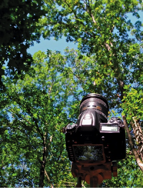
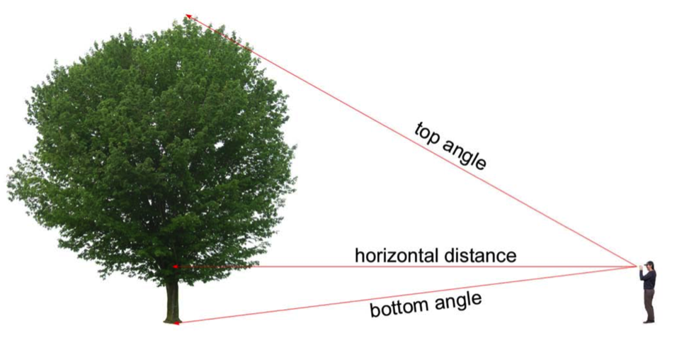
Monitoring, however, can be time-consuming and resource intensive. U.S. Forest Service scientists from the Southern Research Station Utilization of Southern Forest Resources have developed a new piece of software called UrbanCrowns that can be used to assess urban tree crowns and monitor tree health using just a photograph and a few easily collected field measurements (the horizontal distance to the tree, and the vertical angles to the top and base of the tree). The photograph is uploaded into the program and a series of reference lines are drawn on the image; those lines are used to scale the image and delineate portions of the crown. The program then analyzes the single, side-view digital photograph and calculates the height, diameter, ratio, volume, density, and transparency (or light transmittance) of the crown.
Using this relatively small amount of input, UrbanCrowns can detect changes in crown conditions for broadleaf and coniferous trees and then use those changes to quantify tree functions and benefits. The program can be used to monitor individual tree growth or decline over time, detect disease or insect damage in early stages, and provide data to quantify tree benefits such as carbon sequestration, rainfall interception, energy conservation, pollution removal, and oxygen production.
Initially intended to be a tool for assessing forest health, the researchers had difficulty with the digital photography method due to background vegetation obstructing the photos. Forestry Technician for the Forest Service and lead author of the UrbanCrowns report, Matt Winn, states: “We also realized that while this method was not very practical in a forest setting, it was very well suited for urban environments where there are fewer obstructions and little interference from background vegetation. That’s when we shifted our focus from individual forest trees to urban trees.”
Assessment methods for urban trees without a program like UrbanCrowns use a combination of ground-based measurements and visual estimation of tree features – however, tree crowns can be difficult to assess from ground level and the visual assessment can be subjective. As Matt Winn put it, “UrbanCrowns was developed to provide a more objective and accurate approach to urban tree crown assessments.” The software can be used by anyone, with or without a background in urban forestry, to analyze urban tree crown characteristics using only a digital photograph and a few easily collected field measurements.
Takeaways
These intuitive, practical, and cost-effective tools can be used by anyone in their efforts to plan, evaluate, and quantify the benefits of their urban forest.
Understanding which tree to select and where to place it on a site will help avoid infrastructure conflicts as the tree matures. Monitoring and assessment of individual tree growth will guide efficient maintenance and care decisions. Because the social, environmental, and economic benefits of trees are directly related to their size and health, information on urban tree growth is indispensible to understanding urban forest function and value. A better understanding of tree growth can potentially reduce management costs, improve functional performance, and increase the benefits derived from healthy urban forests.
Resources
McPherson, E. Gregory; van Doorn, Natalie S.; Peper, Paula J. 2016. Urban Tree Database and Allometric Equations. Gen. Tech. Rep. PSW-GTR-253. Albany, CA: U.S. Department of Agriculture, Forest Service, Pacific Southwest Research Station. 86 p.
Meznarich, Paul. “Selecting Trees to Grow in Cities.” U.S. Department of Agriculture, Forest Service, Pacific Southwest Research Station. 03 November 2016, https://www.srs.fs.usda.gov/compass/2016/11/03/selecting-trees-to-grow-in-cities/.
Winn, Matthew F.; Araman, Philip A.; Lee, Sang-Mook. 2011. UrbanCrowns: an assessment and monitoring tool for urban trees. Gen. Tech. Rep. SRS-135. Asheville, NC: U.S. Department of Agriculture, Forest Service, Southern Research Station, 10 p.
Stephanie Marino is a landscape architect.
Michael Verhoef / CC BY-NC-ND 2.0



Fascinating article – thank you Stephanie. I can definitely see how the application of this would be a great a help in the correct planning of urban landscapes and help prevent unnecessary and expensive tree damage. Have you used this software in your own landscape designs?
Thank you for the kind comment. I’m glad you enjoyed the article. I have not personally used the tools, however I did learn from the developers that there has been much interest in the software. I hope this article helps get the word out about the capabilities and we see more examples of it in use in the future!