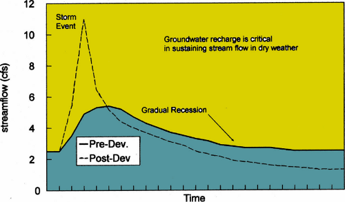
 This hydrograph (diagram showing runoff flow versus time) compares the intense spike of a stream during a storm in an urbanized watershed without adequate controls, with the “gentle rolling hill” appearance of a forested watershed’s response to the same storm. Note the loss of dry weather base flow for the stream in the urbanized watershed.
Maintaining or mimicking pre-development hydrology is a narrative standard used by stormwater project designers. “Pre-development hydrology” refers to the way in which a naturally-vegetated area handles precipitation, and is an important goal for sustainable and environmentally thoughtful design. I want to discuss what those functions are — and why their preservation is so important.
When a vegetated watershed is deforested and paved, its streams get “flashy,” raging during storms and then going dry. Fish and benthos die. Trunk sewers and bridge abutments are scoured. Designers are striving to reverse these trends through increasing use of trees and other vegetation in built environments, and protecting pristine watersheds through preserving forests, soils, and native bedrock structure.
There are at least eight hydrologic functions provided by forests and trees. Below are descriptions of each function; they overlap and percentages do not add to 100%.
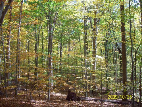
A deciduous forest in early Fall in Montgomery County, Maryland (Little Bennett Regional Park,
near Frederick County) illustrates the leaf canopy and understory of deciduous trees that capture precipitation via interception and stemfall.
1) Canopy Interception: The leaves of trees and large shrubs act like umbrellas or shallow cups that collect rainwater and other precipitation; they typically capture (reduce) about 10% of total annual precipitation in a healthy forest; this function varies according to whether deciduous or evergreen trees are dominant.
2) Stem flow: The limbs and trunks of trees and shrubs provide year-round capture and delays in peak flows; some studies estimate that stem flow in a dense forest captures as much as 15% of annual precipitation.
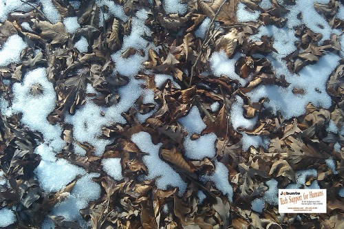
3) Leaf Litter Absorption: The duff (dead leaf) layer stores and transmits water and protects the underlying soil from erosion; it is estimated to absorb 2 to 4% of annual precipitation.
4) Soil Infiltration: Native soils with ample organic layers are the “sponges” of healthy ecosystems; their pore spaces store water and infiltrate it vertically and laterally, interact with root and fungi systems. 80 to 95% of annual precipitation in forests is captured via soil infiltration; it’s the master hydrologic function of forest ecosystems, governing evapotranspiration; hydraulic lift; groundwater recharge; and large storm conveyance.
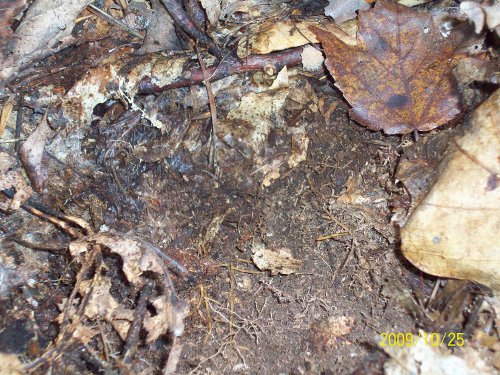 A view of the upper layers of top soil in a second-growth deciduous forest (Little Bennett Regional Park in Montgomery County, MD). Note the dark blackish-brown soil color indicating high organic content, and the density of fine root filaments that provide structure and porosity to make the soil more “spongy” — and thus able to store and transmit higher quantities of precipitation.
5) Evapotranspiration: Trees but also shrubs and forbs release large amounts of water vapor through their leaves during photosynthesis. Total runoff is significantly less for a forested watershed compared to an urbanized one. Evapotranspiration also reduces pollutant loadings and cools the air. Nationwide, evapotranspiration has been estimated to capture 57% of average annual precipitation. Evapotranspiration from plants, along with evaporation from water surfaces, accounts for two-thirds of the precipitation falling on the lower 48 States (Dunne and Leopold (1978) Water in Environmental Planning, p.127. Evapotranspiration also reduces pollutant loadings, and cools and cleanses the air.
6) Hydraulic Lift/ Redistribution: First documented in the mid-1990s, tree roots in bothArizona andNorth Carolina have been shown to lift groundwater from deeper layers and bring it closer to the surface, where it can be used by other plants as well as the trees themselves. Hydraulic Redistribution was shown to account for up to a fourth of the precipitation reduced annually in a North Carolina coastal plain pine forest. (Domec et al. 2010 New Phytologist (2010) 187:171-183; (Thanks to Scott Dierks and Robert Goo for bringing hydraulic lift to my attention.)
7) Groundwater Recharge: Recharge refers to replenishment of both groundwater (aquifer) levels and dry weather stream flows. Tree roots in symbiosis with fungi enlarge fissures in bedrock, increasing porosity and groundwater recharge capacities. (Graham et al, (2009) Rock to Regolith Conversion, Geological Society of America). Since groundwater recharge is complex, soil infiltration is used as a surrogate for recharge.
8 ) Conveyance of Large Storms: A well-vegetated catchment conveys runoff from large storms in multiple, distributed channels. Heavy rainstorms, including 100-year storms saturate the soil layer and then cause shallow subsurface flow (interflow); this outcrops as seeps and springheads of temporary rivulets and ephemeral streams.
Designers can meet higher stormwater requirements, including at ultra-urban sites, through use of green roofs; green walls; shade trees and forest protection/ reforestation; soil decompaction; conservation landscaping and bioretention. These can provide many or all of these pre-development hydrologic functions, thereby diminishing any negative impact on the surrounding environment and nearby water bodies.
Images: Joseph Horgan and Diane Cameron






Leave Your Comment