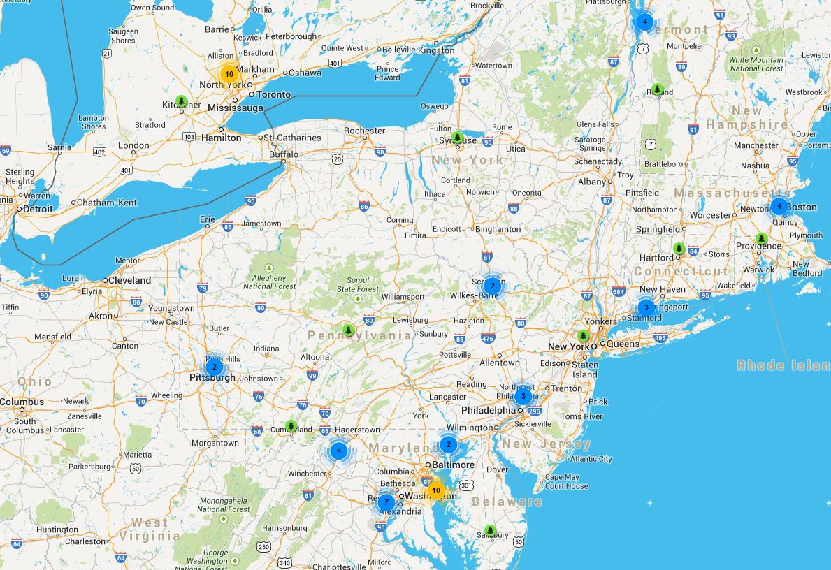
In 2010, my colleague Peter MacDonagh attended the American Society of Consulting Engineers (ASCE) conference and emerged with a chart from a presentation given by Bram Gunther and Fiona Watt, of the New York City Department of Parks, that listed the urban tree canopy information for about two dozen U.S. cities. Ever since then, I’ve wished for a central resource where I could find the urban tree canopy data for even more cities in North America. The information on the chart that Watt and Gunther supplied was a great start, but far from complete. Urban tree canopy statistics aren’t private, but they can be difficult to find, which is why I was so happy when I found the U.S. Forest Service’s Urban Tree Canopy Map.
Using the Forest Service map, you can navigate across the United States to find urban tree canopy statistics for over 60 communities. Click on the tree icons to see the name of the city or town and information on the year of data collection, the status of the collection, the percent of land area, the percent of total area, and the percent of tree canopy goal. Remember to look at “% of land area” rather than “% of total area” if you’re looking for the most straightforward urban tree canopy metric, since some communities contain substantial areas of water.
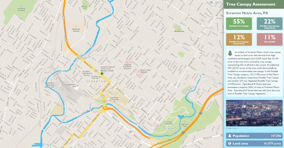
US Forest Service Urban Tree Canopy Map, Scranton, PA detail.
Jarlath O’ Neil-Dunne, the director of the Spatial Analysis Laboratory at University of Vermont, supplies the information for the Urban Tree Canopy Map. He is part of the U.S. Forest Service’s “People and Environment” team, a group that collaborates with local partners to determine how much tree canopy a particular community currently has and how much room they have to plant new trees. According to O’Neil-Dunne, “People have a lot of questions related to how to increase their urban tree canopy goals. Our research shows that private residents own the majority of trees contributing to the urban tree canopy. So the residents are actually some of the most important people we need to reach – it’s not just about planting more street trees.” You have to know what you’re starting with before you can decide where you want to go.

US Forest Service Urban Tree Canopy Map
The data on the USFS urban tree canopy map is all collected by Jarlath and his team. The places where they do data collection is driven by a combination of two factors: which communities have funding, and which also have an interest in working with the Forest Service. Both are essential – the funding for obvious reasons, and the interest because it means that the People and Environment team gets more engagement and buy-in for their work from the outset.
The People and Environment team collects remote high resolution aerial or satellite imagery in conjunction with LiDAR to gather data and uses object-based image analysis to automatically map the tree canopy. Accuracy is extremely important, especially for extrapolating related benefits such as stormwater management and mitigation of heat-island effect. These corollary effects are where the case for more trees and better trees becomes really powerful, and accurate statistics are the basis of it. When doing their urban tree canopy analysis, the team also leverages other data sets about buildings, road, or other paved surfaces that may have been previously collected by the community. The whole mapping process typically takes two to three months.
Once the urban tree canopy statistics have been determined, the team ties what they find back to the community’s particular planning process by suggesting prioritization areas for tree planting. For example, surface temperatures are much lower where trees are present, which the People and Environment Team can then target and correlate with at-risk populations (for example, the elderly) to advise areas to plant first. While this is great, it can also bring challenges. “Agencies have different priorities, so you have to find the common ground between them,” said O’Neil-Dunne. “But,” he went on, “that’s what wonderful about mapping data – it’s very easy to organize and re-organize and look at the same data is various different ways. Field surveys are also important, because they can help you find out more specific information about species, tree health, are more. They are complementary approaches.” How closely they collaborate once data collection is complete varies: some communities want to do all the planning themselves, and some are open to working together to hear and implement the suggestions of the People and Environment team.
You may notice that when you click on some of the locations listed on the Forest Service map, they don’t contain any statistics– that’s because the map is currently being updated, so if that happens, check back soon. So far, they have completed projects in 63 communities in the United States, and the hope is to continue doing more. Jarlath observed, “The challenge for trees is that the lifecycle of a tree is many times the lifecycle of a politician. We won’t really see the results for many, many, many years.”
If you have a community grant for urban tree canopy data, and you want work with the People and Environment Team to help determine your city or town’s statistics, you can email Jarlath directly ([email protected]) to learn more.


We have a new UTC project map up with new and improved functionality.
http://gis.w3.uvm.edu/utc/
Thanks for letting us know! I’d love to update the post. Is there a way to embed the new map? It appears at first glance that I can only link to it (which I will do).